

The following was originally published over at Hidden Waters Blog, a companion blog to the amazing Hidden Waters of NYC book by Sergey Kadinsky, and reprinted with permission.
It’s a fascinating look into our borough’s past and a search for the Kingsbridge neighborhood’s namesake: The King’s Bridge.
What do you know about this part of our borough’s history?
In search of the historic King’s Bridge on Bronx-Manhattan border
The oldest active bridge in New York City isn’t Brooklyn Bridge. It is the Roman-inspired High Bridge that connects western Bronx to the Washington Heights neighborhood of Manhattan. Further north there was a much older bridge that connected Manhattan to the mainland. King’s Bridge crossed over Spuyten Duyvil Creek that passed by the northern tip of Manhattan.

In the above 1906 photo of King’s Bridge, the crossing appears virtually unchanged from its appearance in 1766 when it opened as part of Albany Post Road. The creek was buried and rerouted in 1914, but are there any traces remaining of the city’s first bridge?
Where it Was

On the 1887 Edsall historical survey of this area, I highlighted the present path of Spuyten Duyvil Creek and circled King’s Bridge in orange. The knob of land between the highlight and the bridge is Marble Hill. To its east in red is Albany Crescent, a remnant of the old Albany Post Road. I also noted School Brook and Bronx River, which I’ve written about in prior posts.
This map is the Bronx equivalent of J. H. Innes’ 1908 Queens maps, which attempt to recreate the landscape at it appeared when the Natives were pushed out and the earliest European landowners staked their claims. The Native name for Spuyten Duyvil appears as Shorach Kappock, with 1645 as the year of “acquisition.” The Kingsbridge neighborhood appears as Paparinamin. The largest property on the map is the Manor of Fordham, which remains on the map as a neighborhood and street name.

The old bridge dates to 1693, constructed by Frederick Philipse at a spot known to Natives as the Wading Place, the narrowest point on the creek between Manhattan and the mainland. As Lord of Philipse Manor, he ruled over a vast property that stretched along the Hudson from Spuyten Duyvil Creek to the Croton River, with slave labor working on its farms, gristmills, and docks. The bridge’s name was given out of loyalty to the king and the toll exemption given to British military personnel. As the family was loyalist, the property was confiscated and subdivided during the American Revolution. By then, the competing toll-free Dyckman Bridge on 225th Street had siphoned most of the traffic from King’s Bridge.
Straightening Spuyten Duyvil

As early as 1817 when the Erie Canal was under construction upstate there were plans to straighten Spuyten Duyvil Creek. That year a narrow ditch was carved in the lowland separating Marble Hill from Inwood. But at only 4 feet in depth, it could not transport anything larger than a small boat. On the 1892 map above, the planned shortcut is labeled as “Government Cut in Progress.” The three highlighted bridges across Spuyten Duyvil Creek are King’s Bridge, the new Broadway bridge, and Dyckman’s Bridge.

That year engineer Louis A. Risse published a survey of the shortcut canal and Spuyten Duyvil Creek along with a grid of streets that would gradually cover the landscape. Annexed by New York City in 1873, the streets of western Bronx were an extension of the Manhattan grid, interrupted in many places by topographical obstacles. The rail line curving around the creek is the Hudson Line while the one running straight is the Putnam Line, which was abandoned in 1980. highlighted is Tibbett Brook, which was covered in the early 1900s. Tibbett Avenue runs atop the former waterway. Risse is a familiar name in Bronx cartography, having laid out the route of Grand Concourse.
Last Photos at King’s Bridge

From the Municipal Archives collection, city photographer Eugene de Salignac visited King’s Bridge on October 21, 1913 to document progress on the filling of the creek. The bridge is show running across land. Its wooden planks have been removed with paving stones to arrive by the end of the day. In the background a “for sale” sign on Dyckman Estate. After more than two centuries in the neighborhood, the family’s sizable property was shrinking as urbanization was reaching Kingsbridge. The gothic revival building on the hilltop is Saint John’s Roman Catholic Church.

Another view taken on that day shows a horse-drawn cart delivering paving stones for the roadway. On the side are wooden planks that were removed from the former bridge. A survey of the creek published a year earlier is detailed enough to show a sandbank near the bridge. It had the name Godwin’s Island after a nearby landowning family. Perhaps the smallest island in the city, although there are plenty of other named rocks and sandbanks in the city’s waterways.

The view north on the site of King’s Bridge would be unrecognizable to De Salignac. The Manhattan-Bronx border runs across the road here. At the border, Marble Hill Avenue becomes Kingsbridge Avenue. On the right is Marble Hill Playground, built in the 1950s together with the nearby NYCHA Marble Hill Houses.
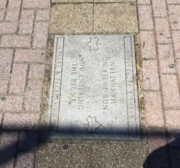
The playground appears standard and likely in need of an update. One unique element here is the paving stone indicating the Manhattan-Bronx border that runs through this 1.65-acre park.
As a tour guide, I can brag about standing atop Mount Marcy and Todt Hill. I also straddled the New York-Quebec borderline. Now I can say the same after visiting Marble Hill Playground. The paving stone is likely an idea of Parks Commissioner Henry Stern, who ran the parks from 1983 to 1990, and again from 1992 through 2000. He gave names to the unnamed playgrounds and green traffic triangles. This border stone seems like something he would have done.
Broadway Crossing
 With the grid imposed on northwest Bronx, the old Road to Kingsbridge and Albany Post Road were straightened as the northern extension of Manhattan’s Broadway.
Remnants of the old roads appear today as Marble Hill Road, Albany Crescent, and further north as Post Road. Of particular note, the ornate railing and light fixtures on this bridge, highly detailed at a time when public structures were renowned as works of art.

Zooming in on this 1901 shot of Broadway at Spuyten Duyvil Creek, we see the plant-like curls and spiral roundels that would have made this bridge a landmark had it survived to this day. Further downtown, the stations on the Third Avenue El featured similar nature-inspired art on their railings and stained glass windows. I describe this bridge as Broadway crossing so an not to confuse it with Broadway Bridge, which was built in 1895 when the shortcut canal was completed. For a time Marble Hill was an island between the old creek and the new canal but by 1913 the old Spuyten Duyvil Creek was entirely filled and the fancy bridge above was dismantled. Its railings disappeared.
Searching for the Bridge

In 1929, De Salignac visited the site of the former bridge, taking photos from atop the former creek. The elevated tracks were built here in 1906, serving the 1 subway line. They descend below the surface at Dyckman Street, terminating at South Ferry.

On the wall of the public housing project facing Broadway is a plaque commemorating the Original King’s Bridge, used by Gen. George Washington on his northward retreat in 1776.
The northern tip of Manhattan was dotted with forts built by patriots to defend their newborn nation. Some were renamed by the British upon capture. The collection included: Fort Washington, Fort George, Cox’s Hill, Fort Prince Charles, Fort Number 4, and Negro Fort.
Some of the forts became parkland while others were forgotten beneath layers of urban development.
Dyckman’s Bridge

The third bridge across this vanished stream was Dyckman’s Bridge, built in 1758 by Jacob Dyckman as the toll-free alternative to King’s Bridge.

Muscoota Street led to Dyckman’s Bridge, a local Native name that was later applied to a marsh bordering on Inwood Hill Park. With the extension of the Manhattan grid into the Bronx, it was numbered as W. 225th Street.

The last photo of this bridge dates to 1910, where it is labeled as Farmers Bridge. In the background the elevated tracks run above Broadway. This section of Spuyten Duyvil Creek was filled in the following year. The scene today would also be unrecognizable to Dyckman. In the foreground today is a Target shopping center and on the other side of the road are public housing towers.

Today’s W. 225th Street retains one element from Dyckman’s Bridge: the mid-block bend on its way east as seen in the above 1910 map from Municipal Archives. The other bridge on the map above is Broadway Bridge. From 1922 through 1930, the filled land on the south side of Dyckman’s Bridge was the site of New York Velodrome, a 16,000-seat circular arena for bike racing and boxing. MyInwood blog tells its story in detail.
The Exact Border
Comparing the 1930 and 1955 G. W. Bromley maps from the NYPL Digital Collections, we see the lines marking the former shoreline of the creek, highlighted route of the road to King’s Bridge, and the Morse-like border line (.___.___.) separating Manhattan from the Bronx. I have not spoken to residents of apartment buildings that straddle this line but I presume their addresses are based on the streets that face their buildings.
King’s Bridge has been buried for more than a century. Its name lives on in the Kingsbridge neighborhood and Kingsbridge Avenue.
About the Author
Sergey Kadinsky is an analyst at the New York City Department of Parks & Recreation and an adjunct professor of history at Touro College.
He is a licensed tour guide who paid his way through college atop the double-decker Gray Line buses.
Kadinsky is a contributor to Forgotten New York, a local history website. His articles on the city’s history appeared in New York Post, New York Daily News, and Queens Chronicle, among other publications.

